Topography Stereo Pairs (Cross-eyed Viewing)
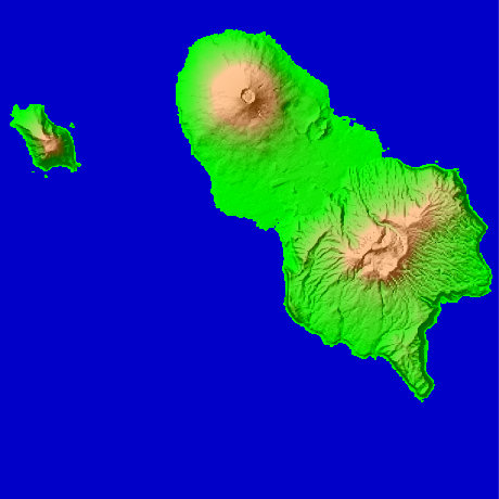
Hachijo Island in Tokyo Japan
Hachijo Island is an island which was located 287km of south marine one in Tokyo, and carried out an area of 69.52 square kilometers, and the gourd type of 58.91km of circumferences. Nishiyama (Hachijo Fuji) (854.3m) of the north side is north latitude 33-degree 8-minute and 15 seconds, and east longitude 139-degree 45 minutes and 57 seconds in the highest peak. As for a southeast part, Mt. Taihei (610.8m) of Kojima of the Higashiyama (Mt. Mihara) (700.9m) west side is the highest in Hachijo Kojima. It can go in 45 minutes to Hachijo Island from Tokyo Haneda Airport.
This figure is 14.6km. Latitude 9-minute and 12 seconds, and longitude 11 minutes and 30 seconds
This figure is 3D CG created by its own program based on the altitude data of "Digital Map 50m Grid (Elevation)" of "Geographical Survey Institute Government of Japan issue."
 Parallel viewing
 ANAGLYPH
All Right Reserved.
No reproduction or republication without written permission.