Topography contents about Digital Map in Japan Home

3D topographical map

.....Last update Aug.10.2006.....
It is 3D Viewing of geographical feature. Geographical feature is usually seen in the height of the eyes. Seeing from right above sees as scenery of the window of an airplane. If this geographical feature is seen by 3D Viewing, in the topographical map by the ordinary contour line, the unevenness which is not understood will appear vividly. If it sees by 3D Viewing also in the mountain which he climbed, ups and downs of the sight and mountain can understand well.

Then, the page of the stereo topographical maps -- please

Click Title of Table !
Title (Click) Contents number Update
Tokai/Kanto area in Japan Mountain of Tokai/Kanto area etc. Large 15 sheet Aug.10.2006
Tohoku area in Japan Mountain of Tohoku area etc. small 10sheet
Large 5 sheet
Mar.28.1999
Kansai area in Japan Mountain of Kansai area etc. small 10sheet
Large 5 sheet
Jun.15.2002
about Digital Map It is explanation about a Digital map. (Text) --- Aug.12.2006

It is the figure near the Mt. Fuji summit which two upper sheets see by Cross-eyed viewing, and two middle sheets see by Parallel-eye viewing. Two lower sheets are Anaglyphs. The left is monochrome and the right is a color Anaglyph. In order to see Anaglyph using red-blue glasses, the figure the object for left eyes and for right eyes is displayed in piles. Regardless of size, it can see easily also in a big figure. For a left eye, red and a right eye are blue.


A summit can jump out to the front.
As for this picture, height is emphasized. If the figure for Parallel-eye viewing is seen by the Cross-eyed viewing, it seems to look up from underground. The view which cannot exist actually becomes possible in CG. For Cross-eyed viewing, Parallel-eye viewing, Please refer to How to Viewing

3D topographical map

The topographical map of this page consists of 450x450 pixels. It will disturb, if screen size is not 1000 pixels or more in width. If wide range geographical feature is Viewing 3D, geographical feature will appear and go up vividly. In a plane topographical map, the feature which is not known is known well.


3D topographical map-related Web
The Geographical Survey Institute (GSI) Business of a Japanese maps are carried out here.
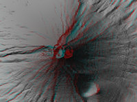
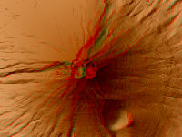
Dr. SatoStereoscopy of Topography with Anaglyph Technology

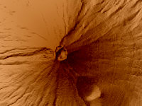
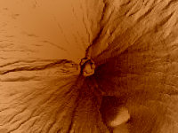
This figure is 3D CG created by its own program based on the altitude data of "Digital Map 50m Grid (Elevation)" of "Geographical Survey Institute Government of Japan issue."

All Right Reserved.
No reproduction or republication without written permission.

Please mail comments and suggestions to My mail
Topography contents about Digital Map in Japan Home